Piston.my

GPS

ACO Tech, the joint-venture company between Proton Edar, Altel Communications and ECARX Hubei Technology, is the company that is involved in the GKUI software in the latest Proton models. Moving forward, the company has now rolled out its next-gen technology – ATLAS (ACO Tech Local Automotive Services) – an in-vehicle infotainment operating system which has been developed with a RM30 million investment.

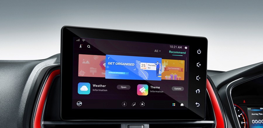
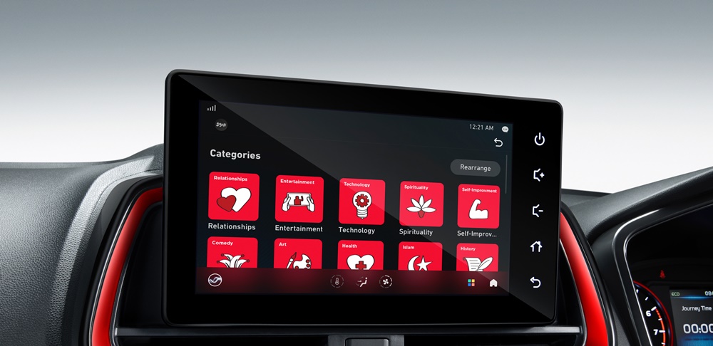
Wholly led and developed by a Malaysian team, ATLAS is supported by a complementary mobile application named ATLAS Auto with features that prioritise mobility, convenience, and control. Specifically designed with personal experience in mind, ATLAS offers entertainment with a myriad of content. It is integrated with JOOX, a dedicated music and entertainment platform as well as  entertainment provider SYOK. Adding to audio experience are the latest hits from all Astro Radio brands and podcasts that cover a wide range of topics in multiple languages.

Malaysian-oriented voice-recognition
Built with an AI-powered speech solution that has the enhanced capabilities to recognize Malaysian English at varying tones and speed, ATLAS is able to respond positively to various commands. This is not always the case with voice command systems that may not take into account how Malaysian speak.

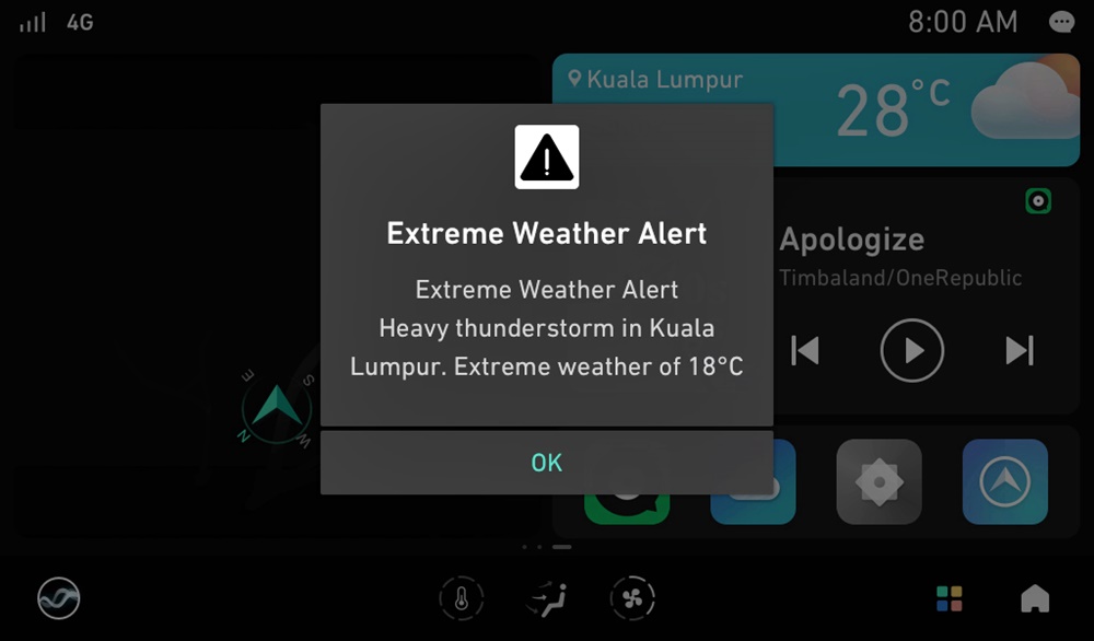
Drivers can therefore stay focussed while driving and still manage the navigation, entertainment, communication, and other vehicle functions. There is an intelligent notification feature to alert the driver if there is extremely bad weather that could affect safety, or when a tyre puncture is detected (subject to other systems also being present). The ATLAS voice assistant can also be customised based on the owner’s preference.

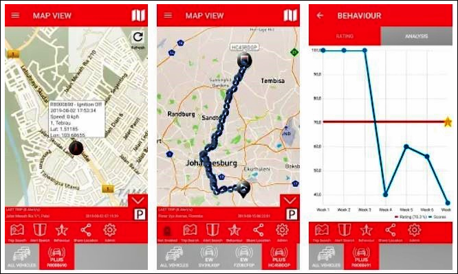
Native navigation system
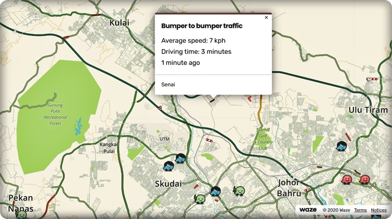
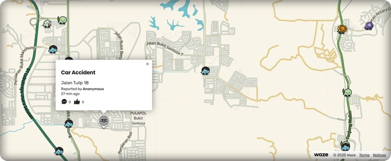
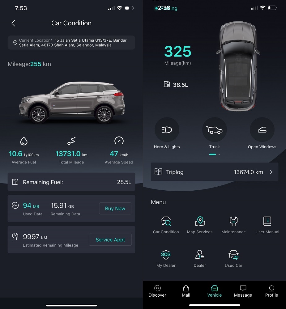
The ATLAS Digital Map is a native navigation system developed by ACO Tech that provides real-time traffic information and has safety-related features. The advanced system is not only able to determine potential traffic patterns to assist drivers to plan their journey, but also able to show weather forecasts and conditions at each point of the route and destination.

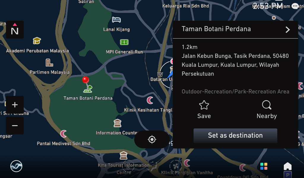
Offline map data allows continued route guidance even if the GPS signal is weak or cannot be received, or the vehicle is in an area without internet access. For convenience, the drivers can send  the vehicle’s location or selected Points of Interest (POI) directly from a smartphone to the vehicle.

You may laugh but there are some people who just do not look at their fuel gauge and are surprised when fuel has run out. ATLAS monitors the fuel level and will provide a prompt to refuel when it detects that there is low fuel remaining. If required, it can also provide guidance to the nearest petrol station (subject to other systems being present).

Easier payment from the car
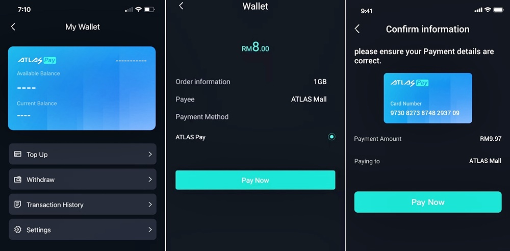
ATLAS will feature ATLAS Pay, an integrated automotive payment system powered by fintech partner Fass Payment Solutions (Fasspay). ATLAS Pay is the first in-car payment in Malaysia and offers the convenience of not having to get out to make payment. It is available in the ATLAS Auto app and will subsequently be integrated with the vehicle’s infotainment system by the first half of 2022. ACO Tech says that, in the near future, ATLAS Pay will be the payment core that introduces its ‘mobility-as-a-service’ vehicle app ecosystem.

ATLAS Pay ACO Tech

The mobile app
ATLAS Auto, a mobile app, will serve as a universal interface to the vehicle. Value-added features such as ATLAS Mall, ATLAS Discover, and ATLAS Vehicle can generate possibilities from brand partners and communities. Available for Android and iOS, it will be available for download from the respect app stores (as well as the Huawei app gallery) from the fourth quarter of 2021.

“ATLAS is intelligent, proactive, and humanised. The eco-system is not only integral in transforming people’s relationship with their car, in-vehicle or remotely; we believe that it underpins the future of automotive user experience and paves the way for autonomous vehicle in Malaysia,” said Li Pu, CEO of ACO Tech.

Full-width displays on dashboard coming soon to more cars


Connectivity is a popular term in use today; in the context of the car, it refers to the ability for different electronic devices to interface and interact. Connectivity in earlier days could be said to have started from the radio sending broadcasts that could be received on the radio in the car. As time went on, drivers could also connect their own devices to listen to a personal selection of music, usually via a cable and then wirelessly by Bluetooth.

Today, connectivity is at a far more advanced level as connections can be made to the internet with wireless broadband services, and smartphone apps can also be mirrored on the infotainment system of the car. The location of the vehicle can also be determined precisely – anywhere on the planet – using GPS (Global Positioning by Satellite) systems.

Today’s connectivity technologies in cars can bring smartphone apps to the dashboard and even connect to the internet for information and entertainment.

Carmakers have used these new technologies to the fullest to make motoring safer and also give drivers more peace of mind. For Toyota owners, the GPS technology is used not only for route guidance and navigation systems that make it easier to find a location but also for enhanced vehicle security.

Toyota Vehicle Telematics System
This is the Toyota Vehicle Telematics System (VTS) available in many models today. It was introduced by the UMW Toyota Motor (UMWT) in 2019. With VTS, the vehicle’s location is monitored using GPS, and its location can be pinpointed on a mobile application. This means that it will be easier for relevant authorities to find the vehicle in the event it is stolen.

Furthermore, VTS is also able to detect an impact experienced by the vehicle. This would suggest an accident, in which case emergency services may be dispatched by the 24/7 command centre to the scene, speeding up rescue actions and perhaps saving a life.

VTS also allows vehicle owners to review their trip history with minute-to-minute reports. They can know the distance covered and overall duration of their journey – useful for those who make claims for travelling expenses. The mobile application. Which can track multiple vehicles, can also review driving patterns during each journey as well as set driving parameters as safety measures with younger or new drivers.

“Connected mobility is a concept that is revolutionizing the automotive industry and it  essentially brings greater peace of mind with the ownership of a car. This enables the driver to form  somewhat of a personal and unique relationship with his vehicle, an interaction that was never available 20 to 30 years ago,” said Ravindran K., President of UMW Toyota Motor.

Toyota’s use of connectivity technologies provides more peace of mind when travelling long distances as assistance is immediately available should an emergency occur.

Toyota 24Seven Road Assist
UMWT also offers vehicle owners Toyota 24Seven Road Assist via its mobile application, an industry first. This is an evolution of what used to be ‘a call away’ for around-the-clock roadside assistance. With almost everyone having a smartphone these days, the mobile app is more convenient and all it takes is just a few swipes on the phone to get immediate assistance.

“We have been providing our customers with Toyota 24Seven Road Assist for the last 20 years. This is a service that continually undergoes enhancements to ensure that they never have to  worry when they are on the road. As mobile technology grows more advanced, naturally the next logical step would be to introduce a mobile application that would bring this service to the next higher level,” said Mr. Ravindran.

Toyota 24Seven Road Assist is not just for the time when accidents occur but can even be called upon if the vehicle has run out of fuel or has a puncture. This is certainly a welcome support service when on a long journey. A request via the mobile app will bring help quickly and because the location is known via GPS, it is easier for the support team to find the vehicle.

Free minor on-the-spot repairs and nationwide towing (up  to 50 kms) are offered to all Toyota owners using Toyota 24Seven Road Assist (terms and conditions apply).

A key  feature built into the mobile app is an SOS button with a real-time tracking feature. Users have the ability track the travel route and time of the help that is on the way to  them. Further assurance is in the fact that the help is from a trusted authorised Toyota outlet or service provider. If necessary, Toyota’s Freephone number 1-800-888-247 can be used to speak to a human operator, 24 hours a day, every day of the year.

“As technology advances, so will cars. This is inevitable, and we have seen vehicles rapidly evolving over the last 20 to 30 years to becoming increasingly safer, cleaner, more economical, offering better performance, to now growing even more intelligent and are able to provide greater forms of interaction with the driver. Suffice to say that transportation and communication will become increasingly reliant on one another moving forward in an era of seamless and connected mobility,” said UMW Toyota Motor Deputy Chairman, Akio Takeyama.

UMW Toyota Motor introduces Toyota Synergised Mobility to present a new aspect of the brand

StayAtHome

Although Malaysia has a railway system network that is pretty old (the first line was built in 1885), most of the places where the lines crossroads usually have barriers. This is unlike Japan or America, with a more extensive network where railway lines crossroads in many places and have no barriers. It is obvious that such crossings require motorists to be alert, especially those without barriers.

While Malaysian motorists may not have to worry so much about railway crossings as there are barriers which come down when a train is about to cross, it is still good to be aware of them when driving, especially in an unfamiliar area. It may seem obvious when a train is approaching but there will still be some people who somehow don’t notice and put themselves at great risk if there is no barrier.

A railway crossing in Wakaf Bharu, Kelantan. Most railway crossings in Malaysia are either elevated (below) or go through tunnels below the road, causing no disruption to traffic flow.

Driver alerted near railway crossing
To make things safer, Waze has marked all the railway crossings in the country, as it does for many other countries. Besides the location being identified, there is now also an alert as the vehicle approaches the railway crossing. A banner will appear on the Waze app highlighting the crossing and advising the driver to approach with caution.

“The Railroad Crossing feature is a result of a cross-industry, cross-sector collaboration, both internally within Waze and the community, working together to help fellow drivers map out all highway-railroad intersections,” said Dani Simons, Head of Public Sector Partnerships, Waze. “This feature exemplifies Waze’s commitment to building for its Driving app, being the first to implement features and emphasizes our focus on safety.”

BHPetrol Euro5 Diesel

Other benefits of using Waze
For those who have not used Waze yet, it is an app which is very useful for motorists – even those who drive within their own town or city and believe they are familiar with all the roads. Besides the route guidance to a specified destination, the route that is suggested is usually the fastest one. It is based on real-time traffic conditions along the way. Sometimes, the route may take you through what seems like a less direct route but actually, it is guiding you to avoid an area where there is congestion.

Another feature which motorists will find useful is the notification of accidents ahead. These obviously are events which cannot be embedded as data since they occur randomly. So Waze invites people to send a notification that is then recorded and made known to everyone else. This alerts the driver to possible congestion ahead (people slowing down to look at the numberplate!) or even the presence of a disable vehicle in a lane that can be a dangerous obstruction.

Speed limits are also indicated so you are aware and don’t exceed them. Motorists will also notify Waze of police roadblocks or ‘other activity’ so that they can expect to slow down as vehicles queue up.

Waze is free for download to mobilephones or other devices that run on Apple’s iOS or Android systems. With more and more new vehicles coming with Android Auto and Apple CarPlay for connectivity, the Waze app can also be mirrored on the dashboard display and accessed from there. This means that maps are always up to date, unlike the early on-board navigation systems where a new digital map (often costing money) would be needed periodically if you wanted updated information.

Like Google Maps, you can also have it on your desktop or laptop computer. From your desk, you can ‘recce’ an area you are going to so you are familiar with the turnings. The current traffic conditions are also shown, so you can decide what route to take to avoid jams.

Waze Beacons enable GPS signals to be received inside SMART Tunnel

COVID-19

GPS – Global Positioning by Satellite – navigation systems are widely used today and provide motorists with easier route guidance to get to destinations. They can be used anywhere on the planet (provided you have the digital map in the system) as the 24 satellites that encircle the earth provide complete coverage. The systems receive signals from the satellites to determine the exact location of the vehicle.

Because the systems get positioning data from the satellites above, their antennas need to be within ‘line of sight’ in the open. That’s why you may sometimes get a message saying ‘SIGNAL LOST’ on your system when you pass through a tunnel and definitely when you are underground in a basement carpark.

Those who drive through the SMART Tunnel in Kuala Lumpur will be aware of this drawback. While on the long road that runs from Sg. Besi to Jalan Tun Razak and Jalan Imbi, the GPS system will not work as it cannot receive signals. However, some systems do have compass mode which can still provide some positioning capability.

Waze and the company operating the SMART Tunnel have made it possible to bring the signals into the tunnel with Waze Beacons installed. These are Bluetooth-enabled devices that can be transmit signals to GPS systems in cars as they pass by. There are 240 Waze Beacons over 5.2 kms of the tunnel, installed just before the MCO started over 150 days ago.

Waze Beacon
Waze Beacon Distribution
Waze Beacons are small units installed in the walls and send out signals using Bluetooth connectivity.

While U Mobile is involved in the Waze Beacons project for the SMART Tunnel, motorists with compatible smartphones and navigation apps can also access the service at no charge even if they are registered with other telcos.

Incidentally, Waze Beacons are also being installed by TRX City adjacent to the tunnel. Given the network of roads below the large TRX site, the beacons will help ensure better location services, increased driver safety, and better visibility of real-time traffic events while driving underground.

BHPetrol RON95 Euro4M

Waze Beacons was launched in 2016 and the concept has successfully been introduced in the USA, Brazil, France, Italy, Australia, Norway, and Czech Republic. In total, they are found in roughly 260 kms of tunnels and roadways worldwide.

“The Waze team and I are pleased to bring the Waze Beacons Program to Malaysia, the first Southeast Asian country to adopt the technology,” said Gil Disatnik, Waze engineer and Global Lead of the Waze Beacons programme Head of the Waze Beacons Program. “We are excited to bring the Waze Beacons programme to the SMART Tunnel, the very first double decker tunnel in the world to be fitted with Waze Beacons to provide seamless navigation to commuters in Malaysia.”

“Tunnel safety is a very important topic and with better visibility, as well as traffic flow into, through and out of the tunnel, we can help to ensure safer road conditions for all. We look forward to expanding the Waze Beacons programme to other areas in Malaysia and across Southeast Asia,” he added.

Yes, Waze MOTORCYCLE and CAR modes can give you two different routes.

PISTON.MY

Archive

Follow us on Facebook

Follow us on YouTube